File:Aleppo offensive (October 2013).svg

File originale (file in formato SVG, dimensioni nominali 1 207 × 933 pixel, dimensione del file: 4,95 MB)
| Questo file e la sua pagina di descrizione (discussione · modifica) si trovano su Wikimedia Commons (?) |
Dettagli
| Descrizione |
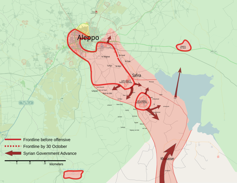
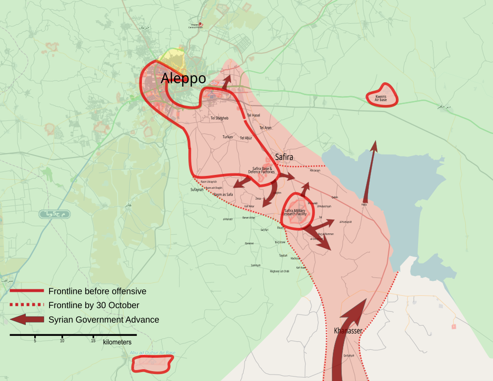
English: Map showing the Aleppo offensive (October 2013).
العربية: خريطة تظهرخطوط الجبهات خلال حملة الهجوم على حلب (أكتوبر 2013). |
| Data | |
| Fonte | Opera propria |
| Autore | MrPenguin20 |
| Altre versioni |
|
.svg&lang=ca)
.svg&lang=en)
.svg&lang=fr)
Ongoing armed conflicts ( Local & City Maps )
|
|---|
|
Local or city Maps of ongoing insurgencies, armed conflicts, disputes of territories, military conflicts, and also current civil or international wars :
|

_Territory_Change_2014-2016.gif)

_(within_Northern_Syria).svg)


.png)
.svg)


_map.png)
.svg)


.svg)


Maps of the civil war in Aleppo ( 2011-present )
|
|---|
|
Local or city Maps of ongoing insurgencies, armed conflicts, disputes of territories, military conflicts, and also current civil or international wars in the governorate and the city of Aleppo :
|


.svg)


.svg)
.png)

.svg?uselang=it)
.svg)
.svg&action=edit)
.svg)
|
Questo file SVG contiene del testo che può essere facilmente tradotto nella tua lingua, utilizzando un editor che supporta SVG (ad esempio un editor XML o di testo). Per maggiori informazioni vedi: Tradurre un file SVG. |
This file is translated using SVG For most Wikipedia projects, you can embed the file normally (without a To translate the text into your language, you can use the SVG Translate tool. Alternatively, you can download the file to your computer, add your translations using whatever software you're familiar with, and re-upload it with the same name. You will find help in Graphics Lab if you're not sure how to do this. |
.svg)
Licenza
| This work contains information from OpenStreetMap, which is made available under the Open Database License (ODbL).
The ODbL does not require any particular license for maps produced from ODbL data. Prior to 1 August 2020, map tiles produced by the OpenStreetMap Foundation were licensed under the CC-BY-SA-2.0 license. Maps produced by other people may be subject to other licences. |
- Tu sei libero:
- di condividere – di copiare, distribuire e trasmettere quest'opera
- di modificare – di adattare l'opera
- Alle seguenti condizioni:
- attribuzione – Devi fornire i crediti appropriati, un collegamento alla licenza e indicare se sono state apportate modifiche. Puoi farlo in qualsiasi modo ragionevole, ma non in alcun modo che suggerisca che il licenziante approvi te o il tuo uso.
- condividi allo stesso modo – Se remixi, trasformi o sviluppi il materiale, devi distribuire i tuoi contributi in base alla stessa licenza o compatibile all'originale.
Cronologia del file
Fare clic su un gruppo data/ora per vedere il file come si presentava nel momento indicato.
.svg&dir=prev)
.svg&offset=20131107071423)
.svg&offset=&limit=20)
.svg&offset=&limit=50)
.svg&offset=&limit=100)
.svg&offset=&limit=250)
.svg&offset=&limit=500)
| Data/Ora | Miniatura | Dimensioni | Utente | Commento | |
|---|---|---|---|---|---|
| attuale | 16:57, 28 nov 2024 | | 1 207 × 933 (4,95 MB) | FrozenCourgette | File uploaded using svgtranslate tool (https://svgtranslate.toolforge.org/). Added translation for fr. |
| 17:32, 22 set 2023 |  | 1 131 × 875 (4,94 MB) | KajenCAT | File uploaded using svgtranslate tool (https://svgtranslate.toolforge.org/). Added translation for ca. | |
| 00:05, 20 nov 2013 |  | 1 131 × 875 (5,21 MB) | MrPenguin20 | Added Aleppo Central Prison to map. | |
| 16:31, 19 nov 2013 |  | 1 131 × 875 (5,21 MB) | U5K0 | sorry... my mistake | |
| 16:18, 19 nov 2013 |  | 1 131 × 875 (5,21 MB) | U5K0 | update | |
| 07:39, 18 nov 2013 |  | 1 131 × 875 (5,21 MB) | BasilLeaf | Factories north of Tall Hasel to Syrian Army کارخانجات شمال تا حاصل در کنترل ارتش سوریه | |
| 17:05, 13 nov 2013 |  | 1 131 × 875 (5,21 MB) | MrPenguin20 | Added line to show frontline as of 30 October (to give sense of evolution of campaign). Brought text for Aleppo and Kweiris Air Base to top layer (was obscured before). Increased size of text for Aleppo and slightly decreased size of text for Safira to... | |
| 18:58, 12 nov 2013 |  | 1 131 × 875 (5,21 MB) | U5K0 | loyalist advance as per http://yallasouriya.wordpress.com/2013/11/12/syria-aleppo-%E2%80%8Fmarkito0171-assad-forces-took-over-last/ | |
| 20:44, 8 nov 2013 |  | 1 131 × 875 (5,21 MB) | U5K0 | base 80 to loyalists per reuters | |
| 08:14, 7 nov 2013 |  | 1 131 × 875 (5,21 MB) | U5K0 | Tall Aran to loyalists per enwp |
Pagine che usano questo file
La seguente pagina usa questo file:
Utilizzo globale del file
Anche i seguenti wiki usano questo file:
- Usato nelle seguenti pagine di ar.wiki.x.io:
- Usato nelle seguenti pagine di ast.wiki.x.io:
- Usato nelle seguenti pagine di ca.wiki.x.io:
- Usato nelle seguenti pagine di en.wiki.x.io:
- Usato nelle seguenti pagine di es.wiki.x.io:
- Usato nelle seguenti pagine di fr.wiki.x.io:
- Usato nelle seguenti pagine di pl.wiki.x.io:
- Usato nelle seguenti pagine di ru.wiki.x.io:
- Usato nelle seguenti pagine di tr.wiki.x.io:
- Usato nelle seguenti pagine di www.wikidata.org:
- Usato nelle seguenti pagine di zh.wiki.x.io:
.svg)