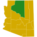
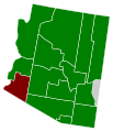
File:Arizona Republican Presidential Primary Election Results by County, 2016.svg

Dimensioni di questa anteprima PNG per questo file SVG: 600 × 600 pixel. Altre risoluzioni: 240 × 240 pixel | 480 × 480 pixel | 768 × 768 pixel | 1 024 × 1 024 pixel | 2 048 × 2 048 pixel | 810 × 810 pixel.
File originale (file in formato SVG, dimensioni nominali 810 × 810 pixel, dimensione del file: 17 KB)
Cronologia del file
Fare clic su un gruppo data/ora per vedere il file come si presentava nel momento indicato.
| Data/Ora | Miniatura | Dimensioni | Utente | Commento | |
|---|---|---|---|---|---|
| attuale | 20:35, 23 mag 2023 | 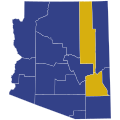 | 810 × 810 (17 KB) | Putitonamap98 | shapes |
| 19:13, 26 dic 2022 |  | 744 × 744 (152 KB) | Putitonamap98 | shapes | |
| 21:42, 20 ott 2020 |  | 277 × 323 (14 KB) | Coffee | No, it isn't, please review File:Arizona_Locator_Map.PNG | |
| 04:48, 20 ott 2020 |  | 277 × 323 (16 KB) | TylerKutschbach | Reverted to version as of 09:03, 25 March 2016 (UTC) we use this for the Arizona maps | |
| 16:56, 19 ott 2020 |  | 277 × 323 (14 KB) | Coffee | Fixing rotation to actually match the longitudes and latitudes of the state. The prior rotation is a confusion created by looking at a globe from the center of the United States, and is simply inaccurate. | |
| 10:03, 25 mar 2016 |  | 277 × 323 (16 KB) | Supernino | fix Navajo county (cf. http://apps.azsos.gov/election/2016/PPE/Results/PPE2016Results.htm) | |
| 21:15, 23 mar 2016 |  | 277 × 323 (16 KB) | Supernino | updated with results | |
| 10:04, 31 gen 2016 |  | 277 × 323 (16 KB) | Oganesson007 | User created page with UploadWizard |
Pagine che usano questo file
La seguente pagina usa questo file:
Utilizzo globale del file
Anche i seguenti wiki usano questo file:
- Usato nelle seguenti pagine di en.wiki.x.io:


