File:Delta WSR (16518033117).jpg

File originale (5 616 × 3 744 pixel, dimensione del file: 12,15 MB, tipo MIME: image/jpeg)
| Questo file e la sua pagina di descrizione (discussione · modifica) si trovano su Wikimedia Commons (?) |
Dettagli
| DescrizioneDelta WSR (16518033117).jpg |
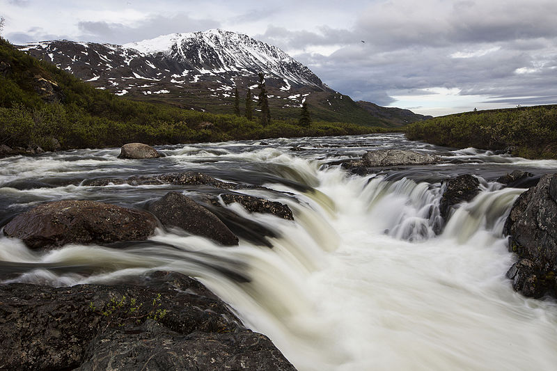
The Delta Wild and Scenic River Watershed originates south of the Denali Highway and includes all of the Upper and Lower Tangle Lakes, the Tangle River, and the Delta River. The Delta River drains north through the Alaska Range, eventually joining the Tanana River and emptying into the Yukon River. The watershed includes 150,000 acres of land, 160 miles of streams and 21 lakes, providing excellent habitat for over 100 species of migrating birds and waterfowl as well as grayling, whitefish, lake trout, burbot, and longnose suckers. Much of the watershed is surrounded by arctic tundra with grasses and sedges makitg it a popular place for berry picking and for migrating caribou. Recreationists who visit during the fall, winter and spring will often witness subsistence hunting and gathering activities. The southern stretches of the Delta Wild and Scenic River Corridor are located within the Tangle Lakes Archaeological District and contain hundreds of archaeological sites listed on the National Register of Historic Places. Use of the area for hunting, mining, and subsisting are evidenced for the last 10,000 years. Learn more: www.blm.gov/ak/st/en/fo/gdo/delta_wild_and_scenic.html Photos by Bob Wick, BLM |
| Data | |
| Fonte | Delta WSR |
| Autore | Bureau of Land Management |
Licenza
- Tu sei libero:
- di condividere – di copiare, distribuire e trasmettere quest'opera
- di modificare – di adattare l'opera
- Alle seguenti condizioni:
- attribuzione – Devi fornire i crediti appropriati, un collegamento alla licenza e indicare se sono state apportate modifiche. Puoi farlo in qualsiasi modo ragionevole, ma non in alcun modo che suggerisca che il licenziante approvi te o il tuo uso.
| Questa immagine è stata originariamente caricata su Flickr da mypubliclands all'indirizzo https://flickr.com/photos/91981596@N06/16518033117. È stata controllata in data 4 agosto 2015 dal robot FlickreviewR ed è stato confermato il suo rilascio sotto i termini della licenza cc-by-2.0. |
4 agosto 2015
| Public domainPublic domainfalsefalse |
| This image is a work of a Bureau of Land Management* employee, taken or made as part of that person's official duties. As a work of the U.S. federal government, the image is in the public domain in the United States. *or predecessor organization |
 |
Didascalie
Elementi ritratti in questo file
raffigura
Valore sconosciuto senza un elemento Wikidata
19 giu 2014
Flickr photo ID inglese
Cronologia del file
Fare clic su un gruppo data/ora per vedere il file come si presentava nel momento indicato.
| Data/Ora | Miniatura | Dimensioni | Utente | Commento | |
|---|---|---|---|---|---|
| attuale | 20:05, 4 ago 2015 |  | 5 616 × 3 744 (12,15 MB) | Wilfredor | Transferred from Flickr via Flickr2Commons |
Pagine che usano questo file
La seguente pagina usa questo file:
Metadati
Questo file contiene informazioni aggiuntive, probabilmente aggiunte dalla fotocamera o dallo scanner usati per crearlo o digitalizzarlo. Se il file è stato modificato, alcuni dettagli potrebbero non corrispondere alla realtà.
| Produttore fotocamera | Canon |
|---|---|
| Modello fotocamera | Canon EOS 5D Mark II |
| Tempo di esposizione | 1/2 s (0,5) |
| Rapporto focale | f/22 |
| Sensibilità ISO | 50 |
| Data e ora di creazione dei dati | 22:08, 19 giu 2014 |
| Distanza focale obiettivo | 35 mm |
| Risoluzione orizzontale | 300 punti per pollice (dpi) |
| Risoluzione verticale | 300 punti per pollice (dpi) |
| Software | Adobe Photoshop Lightroom 4.4 (Macintosh) |
| Data e ora di modifica del file | 06:26, 21 ago 2014 |
| Programma di esposizione | Priorità al diaframma |
| Versione del formato Exif | 2.3 |
| Data e ora di digitalizzazione | 22:08, 19 giu 2014 |
| Velocità dell'otturatore APEX | 1 |
| Apertura APEX | 8,918863 |
| Correzione esposizione | 0 |
| Apertura massima | 3 APEX (f/2,83) |
| Metodo di misurazione | Pattern |
| Caratteristiche e stato del flash | Il flash non è scattato, rimozione flash forzato |
| Data e ora di creazione, frazioni di secondo | 18 |
| Risoluzione X sul piano focale | 3 849,2115384615 |
| Risoluzione Y sul piano focale | 3 908,1418439716 |
| Unità di misura risoluzione sul piano focale | pollici |
| Elaborazione personalizzata | Processo normale |
| Modalità di esposizione | Bracketing automatico |
| Bilanciamento del bianco | Bilanciamento del bianco automatico |
| Tipo di acquisizione | Standard |
| Numero di serie della fotocamera | 320103926 |
| Obiettivo utilizzato | EF16-35mm f/2.8L II USM |
| Valutazione (su 5) | 3 |
| Data in cui i metadata sono stati modificati l'ultima volta | 23:26, 20 ago 2014 |
| ID univoco del documento originale | 1A5BBDD731FE2C8365E63CF349BC6415 |
| Parole chiave |
|
| Versione IIM | 4 |
