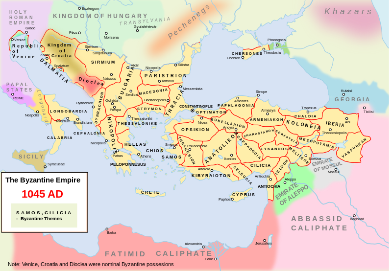
File:Map Byzantine Empire 1045.svg

Dimensioni di questa anteprima PNG per questo file SVG: 800 × 554 pixel. Altre risoluzioni: 320 × 222 pixel | 640 × 443 pixel | 1 024 × 709 pixel | 1 280 × 886 pixel | 2 560 × 1 772 pixel | 1 300 × 900 pixel.
File originale (file in formato SVG, dimensioni nominali 1 300 × 900 pixel, dimensione del file: 428 KB)
Cronologia del file
Fare clic su un gruppo data/ora per vedere il file come si presentava nel momento indicato.
| Data/Ora | Miniatura | Dimensioni | Utente | Commento | |
|---|---|---|---|---|---|
| attuale | 17:06, 11 feb 2024 |  | 1 300 × 900 (428 KB) | Manlleus | File uploaded using svgtranslate tool (https://svgtranslate.toolforge.org/). Added translation for ca. |
| 12:06, 10 feb 2024 |  | 1 300 × 900 (428 KB) | Leptictidium | File uploaded using svgtranslate tool (https://svgtranslate.toolforge.org/). Added translation for ca. | |
| 12:01, 10 feb 2024 |  | 1 300 × 900 (428 KB) | Leptictidium | File uploaded using svgtranslate tool (https://svgtranslate.toolforge.org/). Added translation for ca. | |
| 09:03, 10 feb 2024 |  | 1 300 × 900 (428 KB) | Leptictidium | File uploaded using svgtranslate tool (https://svgtranslate.toolforge.org/). Added translation for ca. | |
| 22:24, 9 feb 2024 |  | 1 300 × 900 (428 KB) | Manlleus | minor corrections to catalan translation | |
| 22:16, 9 feb 2024 |  | 1 300 × 900 (428 KB) | Manlleus | added catalan language | |
| 02:44, 25 feb 2019 |  | 1 300 × 900 (335 KB) | Georgiano | fixed borders, names. | |
| 08:33, 29 set 2016 |  | 1 300 × 900 (331 KB) | ArdadN | some corrections | |
| 13:40, 13 mar 2016 |  | 1 300 × 900 (337 KB) | Georgiano | Theodosioupolis (now Erzurum, Turkey) was capital of theme of Iberia | |
| 19:40, 29 gen 2012 |  | 1 300 × 900 (339 KB) | BotMultichillT | {{BotMoveToCommons|en.wikipedia|year={{subst:CURRENTYEAR}}|month={{subst:CURRENTMONTHNAME}}|day={{subst:CURRENTDAY}}}} == {{int:filedesc}} == {{Information |description={{en|1=Own work. The Byzantine empire and its neighbours in 1045. Byzantine administr |
Pagine che usano questo file
Le seguenti 9 pagine usano questo file:
Utilizzo globale del file
Anche i seguenti wiki usano questo file:
- Usato nelle seguenti pagine di azb.wiki.x.io:
- Usato nelle seguenti pagine di ca.wiki.x.io:
- Usato nelle seguenti pagine di de.wiki.x.io:
- Usato nelle seguenti pagine di en.wiki.x.io:
- Theme (Byzantine district)
- Byzantine–Georgian wars
- Talk:Narentines/Archive 2
- Kingdom of Georgia
- User talk:Iberieli
- File talk:Map Byzantine Empire 1045.svg
- User:Sasha l~enwiki/maps
- Wikipedia:Featured picture candidates/November-2008
- Wikipedia:Featured picture candidates/Byzantine Empire in 1045
- Talk:Byzantine Empire/Archive 10
- Timeline of Eastern Orthodoxy in Greece (717–1204)
- User:WildFields/sandbox
- User:Falcaorib/Medieval Empires (1000-1100 AD)
- Usato nelle seguenti pagine di et.wiki.x.io:
- Usato nelle seguenti pagine di fr.wiki.x.io:
- Usato nelle seguenti pagine di ja.wiki.x.io:
- Usato nelle seguenti pagine di ka.wiki.x.io:
- Usato nelle seguenti pagine di ko.wiki.x.io:
- Usato nelle seguenti pagine di lt.wiki.x.io:
- Usato nelle seguenti pagine di mk.wiki.x.io:
- Usato nelle seguenti pagine di ru.wiki.x.io:
- Usato nelle seguenti pagine di sl.wiki.x.io:
- Usato nelle seguenti pagine di sq.wiki.x.io:
- Usato nelle seguenti pagine di sr.wiki.x.io:
- Usato nelle seguenti pagine di tr.wiki.x.io:
- Usato nelle seguenti pagine di uk.wiki.x.io:


