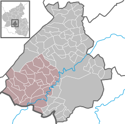
Verbandsgemeinde Birkenfeld
La comunità amministrativa di Birkenfeld (Verbandsgemeinde Birkenfeld) si trova nel circondario di Birkenfeld nella Renania-Palatinato, in Germania.
| Verbandsgemeinde Birkenfeld comunità amministrativa | |
|---|---|
| Localizzazione | |
| Stato | |
| Land | |
| Distretto | Non presente |
| Circondario | Birkenfeld |
| Amministrazione | |
| Capoluogo | Birkenfeld |
| Territorio | |
| Coordinate del capoluogo | 49°39′00″N 7°10′00.01″E |
| Superficie | 213,14 km² |
| Abitanti | 20 434[1] (31-12-2021) |
| Densità | 95,87 ab./km² |
| Altre informazioni | |
| Fuso orario | UTC+1 |
| Cartografia | |
 | |
| Sito istituzionale | |
Comuni
modificaFanno parte della comunità amministrativa i seguenti comuni:
| Comune, città | Sup. (km²) | Abitanti |
|---|---|---|
| Abentheuer | 6,12 | 430 |
| Achtelsbach | 9,70 | 399 |
| Birkenfeld, Stadt | 13,58 | 7 075 |
| Börfink | 8,22 | 163 |
| Brücken | 13,62 | 1 258 |
| Buhlenberg | 8,44 | 478 |
| Dambach | 2,98 | 143 |
| Dienstweiler | 6,69 | 328 |
| Elchweiler | 2,15 | 99 |
| Ellenberg | 2,01 | 96 |
| Ellweiler | 7,46 | 322 |
| Gimbweiler | 5,53 | 385 |
| Gollenberg | 3,25 | 118 |
| Hattgenstein | 8,21 | 246 |
| Hoppstädten-Weiersbach | 17,87 | 3 568 |
| Kronweiler | 3,51 | 306 |
| Leisel | 8,82 | 530 |
| Meckenbach | 3,78 | 113 |
| Niederbrombach | 7,28 | 488 |
| Niederhambach | 9,77 | 328 |
| Nohen | 7,50 | 322 |
| Oberbrombach | 6,56 | 404 |
| Oberhambach | 5,11 | 247 |
| Rimsberg | 3,20 | 117 |
| Rinzenberg | 11,33 | 314 |
| Rötsweiler-Nockenthal | 3,21 | 467 |
| Schmißberg | 1,68 | 205 |
| Schwollen | 8,83 | 427 |
| Siesbach | 7,43 | 362 |
| Sonnenberg-Winnenberg | 2,87 | 422 |
| Wilzenberg-Hußweiler | 6,46 | 274 |
| Verbandsgemeinde Birkenfeld | 213,14 | 20 434 |
(Abitanti al 31 dicembre 2021[1])
Note
modificaAltri progetti
modifica- Wikimedia Commons contiene immagini o altri file su Verbandsgemeinde Birkenfeld
Collegamenti esterni
modifica- (DE) Sito ufficiale, su vg-birkenfeld.de.
| Controllo di autorità | VIAF (EN) 123222986 · LCCN (EN) n85189460 · GND (DE) 4697618-8 · J9U (EN, HE) 987007557626405171 |
|---|

